Since Adirondack Retro acquired Darvill's Rare Prints in August of 2022, we have been working tirelessly on our New State-Of-The Art Website. We are excited to announce that it is now up and running and that our massive inventory of Antique Prints and Rare Maps are being transferred over to the new site daily. In addition to the nearly 500,000 prints found on www.DarvillsRarePrints.com, Adirondack Retro offers an eclectic selection of Antique and Vintage Advertisements along with their Limited Edition Giclee Prints. During this transition, customers will still be able to shop and make purchases on www.DarvillsRarePrints.com.
Sign up for our Mailing List and receive our Adirondack Retro Newsletter. When you sign up, we will email you a coupon code for you to get 15% OFF your first order at AdirondackRetro.com.
Reports of Explorations and Surveys, to Ascertain the Most Practicable and Economical Route for a Railroad from the Mississippi River to the Pacific Ocean.
(Twelve volumes published between 1853-1861)
Exploration and surveys for the Pacific Railroad were carried out under the direction of Secretary of War Jefferson Davis
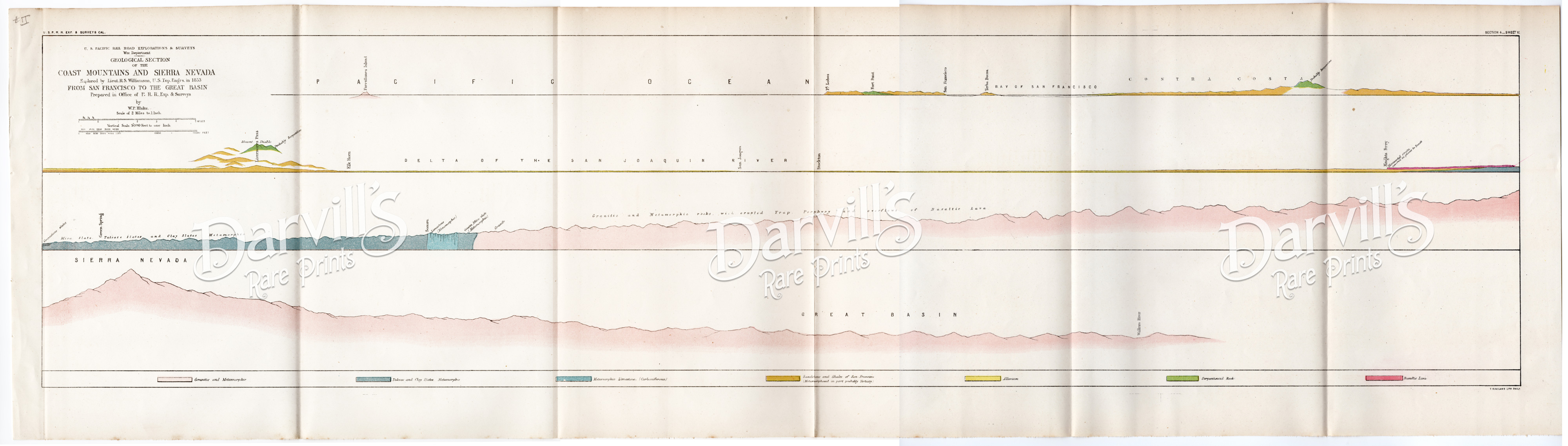
(Note: due to its very large size, the chart has been scanned in sections and digitally "stitched" together, but the chart consists of one continuous sheet with consistent paper tone. Any difference in colors or alignment is due to the nature of trying to provide a comprehensive view from separate scanned pieces.)
REF II
U.S. Pacific Rail Road Explorations & Surveys
War Department
Geological Section of the
COAST MOUNTAINS AND SIERRA NEVADA
Explored by Lieut. R. S. Williamson, U.S. Top. Engrs. in 1853
FROM SAN FRANCISCO TO THE GREAT BASIN
Prepared in Office of P. R. R. Exp. & Surveys
by W. P. Blake
Original 170-year-old Chromolithograph
Sheet size = about 39.5 x 11.125 inches with folds, as issued
$250
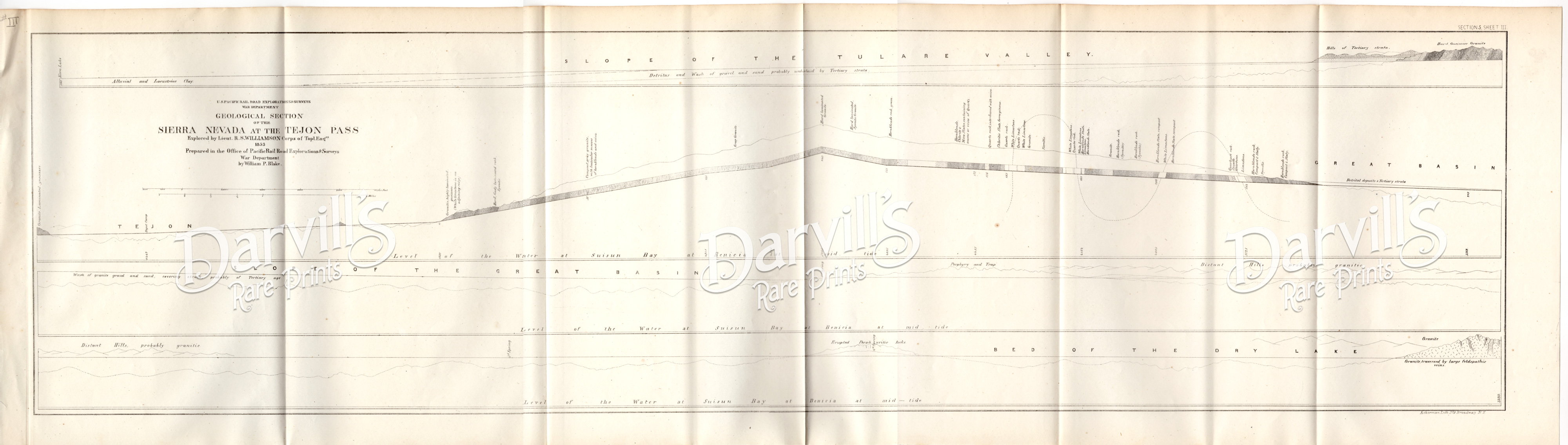
(Note: due to its very large size, the chart has been scanned in sections and digitally "stitched" together, but the chart consists of one continuous sheet with consistent paper tone. Any difference in colors or alignment is due to the nature of trying to provide a comprehensive view from separate scanned pieces.)
REF III
U.S. Pacific Rail Road Explorations & Surveys
War Department
Geological Section of the
SIERRA NEVADA AT THE TEJON PASS
Explored by Lieut. R. S. Williamson, U.S. Top. Engrs. in 1853
Prepared in Office of P. R. R. Exp. & Surveys
by W. P. Blake
Original 170-year-old lithograph
Sheet size = about 39 x 11 inches with folds, as issued
$100
(Note: due to its very large size, the chart has been scanned in sections and digitally "stitched" together, but the chart consists of one continuous sheet with consistent paper tone. Any difference in colors or alignment is due to the nature of trying to provide a comprehensive view from separate scanned pieces.)
REF IV
U.S. Pacific Rail Road Explorations & Surveys
War Department
Geological Section of the
ALONG THE TEJON RAVINE
Geological Section of the
SIERRA NEVADA AT THE CANADA DE LAS UVAS
Explored by Lieut. R. S. Williamson, Corps Top. Engrs.
1855
Prepared in Office of P. R. R. Exp. & Surveys
by W. P. Blake
Original 170-year-old lithograph
Sheet size = about 39 x 11 inches with folds, as issued
$100
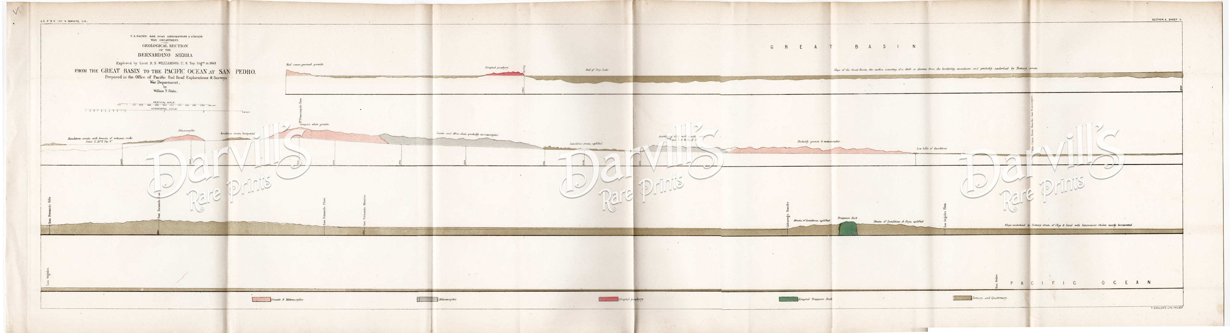
(Note: due to its very large size, the chart has been scanned in sections and digitally "stitched" together, but the chart consists of one continuous sheet with consistent paper tone. Any difference in colors or alignment is due to the nature of trying to provide a comprehensive view from separate scanned pieces.)
REF V
U.S. Pacific Rail Road Explorations & Surveys
War Department
Geological Section of the
BERNARDINO SIERRA
FROM THE GREAT BASIN TO THE PACIFIC OCEAN AT SAN PEDRO
Explored by Lieut. R. S. Williamson, Corps Top. Engrs.
1853
Prepared in Office of P. R. R. Exp. & Surveys
by W. P. Blake
Original 170-year-old chromolithograph
Sheet size = about 40 x 11 inches with folds, as issued
$200
(Note: due to its very large size, the chart has been scanned in sections and digitally "stitched" together, but the chart consists of one continuous sheet with consistent paper tone. Any difference in colors or alignment is due to the nature of trying to provide a comprehensive view from separate scanned pieces.)
REF VI
U.S. Pacific Rail Road Explorations & Surveys
War Department
Geological Section of the
COLORADO RIVER TO THE PACIFIC OCEAN
Explored by Lieut. R. S. Williamson, Corps Top. Engrs.
1853
Prepared in Office of P. R. R. Exp. & Surveys
by W. P. Blake
Original 170-year-old lithograph
Sheet size = about 39.5 x 11 inches with folds, as issued
MINOR FOXING
$100
(Note: due to its very large size, the chart has been scanned in sections and digitally "stitched" together, but the chart consists of one continuous sheet with consistent paper tone. Any difference in colors or alignment is due to the nature of trying to provide a comprehensive view from separate scanned pieces.)
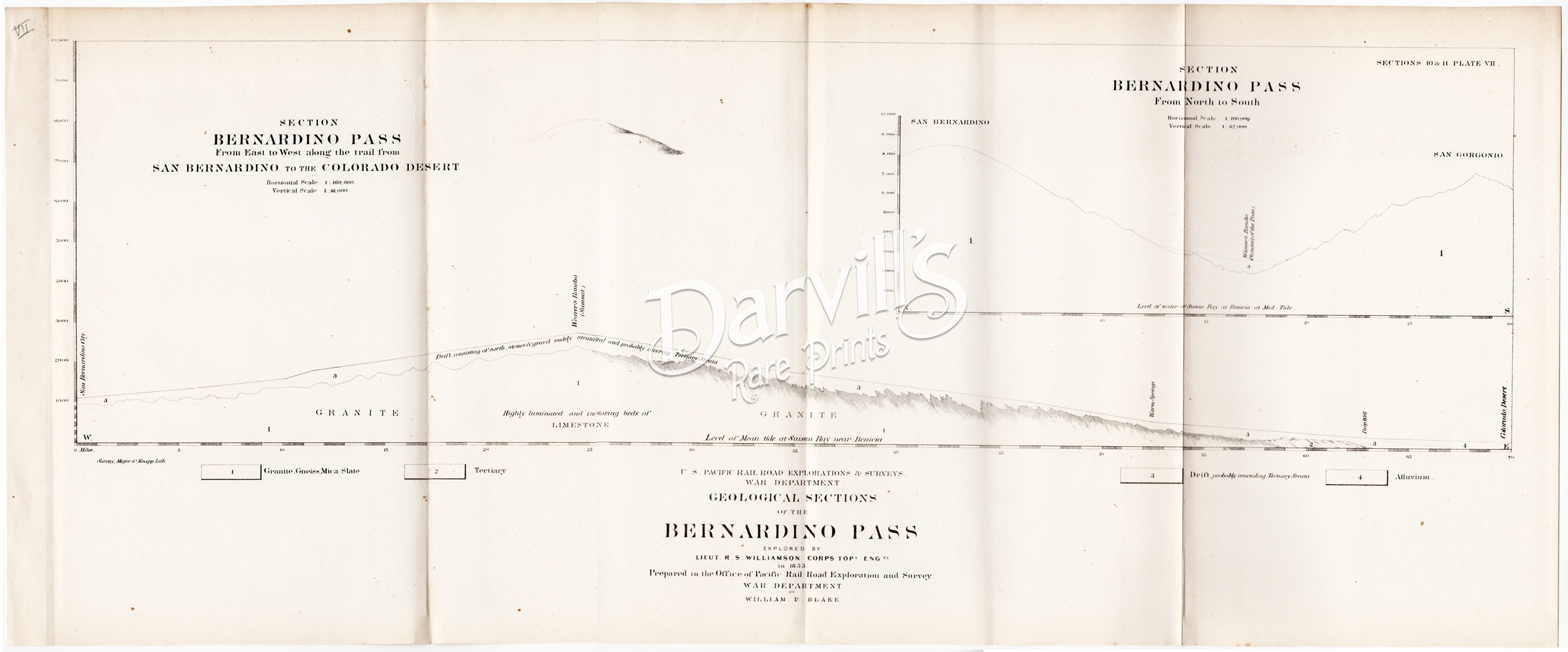
REF VII
U.S. Pacific Rail Road Explorations & Surveys
War Department
Geological Section of the
BERNARDINO PASS
From East to West along the trail from San Bernardino to the Colorado Desert
From North to South
Explored by Lieut. R. S. Williamson, Corps Top. Engrs.
1853
Prepared in Office of P. R. R. Exp. & Surveys
by W. P. Blake
Original 170-year-old lithograph
Sheet size = about 26.5 x 11 inches with folds, as issued
$75
(Note: due to its very large size, the chart has been scanned in sections and digitally "stitched" together, but the chart consists of one continuous sheet with consistent paper tone. Any difference in colors or alignment is due to the nature of trying to provide a comprehensive view from separate scanned pieces.)
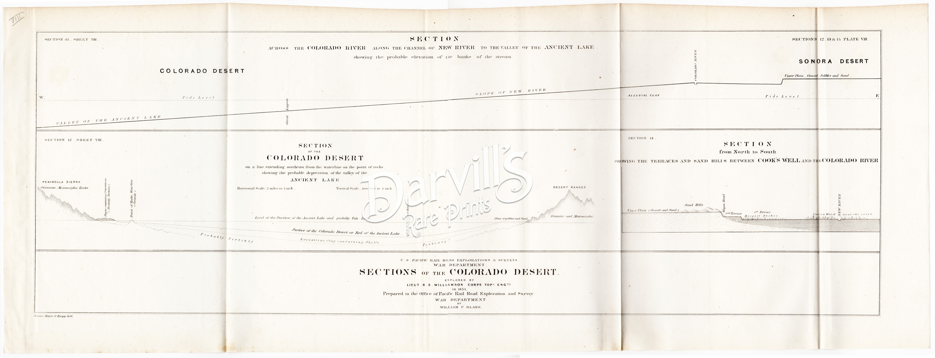
REF VIII
U.S. Pacific Rail Road Explorations & Surveys
War Department
SECTIONS OF THE COLORADO DESERT
Explored by Lieut. R. S. Williamson, Corps Top. Engrs.
1853
Prepared in Office of P. R. R. Exp. & Surveys
by W. P. Blake
Original 170-year-old lithograph
Sheet size = about 29.5 x 11 inches with folds, as issued
$100
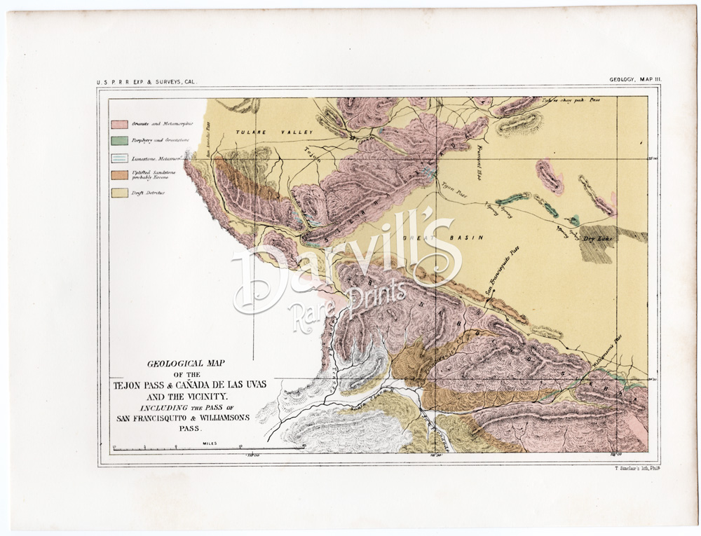
REF IX
U.S. Pacific Rail Road Explorations & Surveys
War Department
GEOLOGICAL MAP OF THE TEJON PASS & CAÑADA DE LAS UVAS AND THE VICINITY
INCLUDING THE PASS OF SAN FRACISQUITO & WILLIAMSON'S PASS
Explored by Lieut. R. S. Williamson, Corps Top. Engrs.
1853
Prepared in Office of P. R. R. Exp. & Surveys
by W. P. Blake
Original 170-year-old chromolithograph
Sheet size = about 11.25 x 8.5 inches

.jpg)